Thursday, 27 October 2011

Eden (Dutch)-Iens (Fries).


Iens, Edens.

We went to Edens (Dutch), Iens (Fries),which falls under municipality of Littenseradiel, it used to fall under the municipality Hennaarderadeel. We went to Iens on 7th January 2008. How ever it changed it name from Edens (Dutch) to Iens (Fries) in 1991, (according to the municipality Littenseradiel).It was a very overcast day, dark clouds, virtually black and threatening to have a down pour at any moment.


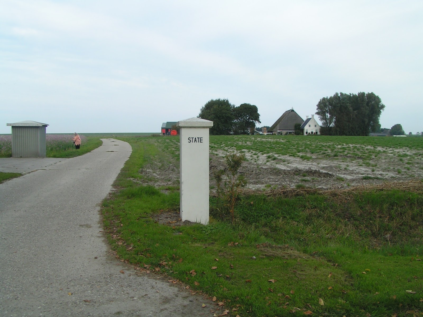
We did not think there would be much to see, when we looked on the map of Iens, it looked like a very small village and that you could not walk or drive through, it  was a dead end village.

It used to be a dead end but today they have built a bicycle path (Fietspad), that runs along the 'Boalserter Feart'.

The people of this village find their work outside the village, as this village is mainly agricultural. Iens is not far from Spannum or Hinnaard.


We parked the car by the church. As we stepped out the car, I turned around and there was the church, I had really expected it to be small, but I was quite surprised to find it was quite large.

A part of this church was built around the thirteenth century and inside the church I beleive there are grave stones to be seen from the sixteenth century. Here are a view different views of the church.


I will try and translate, (though my Dutch is not as good as I would like it to be).

Part of the church and tower date around the 1300's, and in the north wall is clearly of Romanesque design.

The star on the roof of the church is Unique, and where it came from no one knows.

In the 1800's there is talk of the 'star on the church'.

IN 1784 the church was renovated and made bigger, hereby the well (dorpsput), I think that is what it is, was taken out and was laid in the church.

In the church is a engraved stone plaque of 'Bocco van Burmania',(+1553). An Alterstone was found from 1350, during the restorations of the church that took place in 1988-1990 and is once again in use.


I could not beleive that this ball of lighting bolts (that is what it looks like to me), was on top of a church spire. What it represented I do not know, Usually I have come across a hen or ship on top of the church spires, your guess is as good as mine! I have just read it is a 'star', it did look like lightning bolts to me though.


Before the year 1580 all the churches in Friesland were 'Catholic', since then the churches were changed to various other religions, this church was changed to 'Hervormde kerk'.

There was a grave with a head stone that interested me as it had the picture of the church tower engraved or painted on it. Here is a picture below.


There used to be a Land house (Stins), that housed the family 'Van Bumania'. In the church there is a plaque with this family's names and 'Coat of Arms' on.

This village was known to be the birthplace of the 'Fries poet, Piet Idzinga', we found a stone plaque layed in one of the brick walls of a house where he lived, which was in Fries.


De Edensermolen was built in 1847 to drain the Breeuwsma Polder.


There is also the "Sinterklazepleats", about which a legend is told, though I can not find it.

There is a farm (boerderij), named "Sinterklazepleats". whether this is the same as the one mentioned above I do not know.


"Sinterklazepleats" Farm,(boederij),I think. Taken while very overcast.


"Sinterklazepleats" Farm,(boederij).Taken after it cleared.

There were some lovely views from the church cementery.


As we continued our walk through Iens, we came across this house which is really typically Dutch, I just love the roof.


This house had a stone plaque in it, describing who laid the first brick, I come across this quiete a lot in the villages, it is very quaint.


The stone plaque closer up.


As we continued our walk the clouds cleared and thank goodness it did not rain on us.
Here are some more views of the village.


The style of the way this farm has been built, it is referred to in Dutch: Kop, Hals, Schouder, English: Head,Neck, Shoulder.


Main road through Iens.


This house or farm was built in 1742, this you also find a lot in village's with the year on it.


I thought this was so pretty.


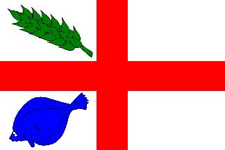
Courtesy of F.O.T.W. (Flags of the World).

Iens village (Edens)

Iens (Dutch: Edend) is a village in Littenseradiel municipality, Fryslân province; it used to be in the former municipality of Hennaarderadeel, with (1958) 69 inhabitants; (1974) 46.

An old road sign read: "Alleen naar Edens" (only to Edens).

There is the "Sinterklazepleats",about which a legend is told.


From Wapens en Flaggen fan Littenseradiel, booklet of the municipality.

Iens CoA: in gold a green "terp" issuing from base, charged with a yellow clover on a branch; on top with two flowers from the fan of a "swanneblom"(a waterlily); in chief a red lion passant.


Image by Jarig Bakker, 11 Sep 2003
adopted 1997; Design: Fryske Rie foar Heraldyk.
Flag: diagonally divided in three stripes of green, yellow and red, with in the canton a yellow flower from the fan of a waterlily. The yellow stripe with 2/5 flagheight.

On the terp of Iens was a "stins" (castle) of the Burmania family.

From the CoA of that family the clover on a branch has been taken.

The flowers have been used as a village-symbol, and were thus used on the new village-CoA.

The lion in chief can be seen on the bell in the village church.

The "swanneblom" flower is named swannepopel", Latin: Butomus umbellatus.

Is that a flower which is only present in "Ever"(as the english translation of "Iens" is)?

Design: Fryske Rie foar Heraldyk, after consultation of the local Society for village-interests "Pleatselik Belang".
Source: Genealogysk Jierboekje 1997.
Encyclopedie van het hedendaagse Friesland, c. 1978.
Jarig Bakker, 11 Sep 2003

Oosterbierum (Dutch)-Easterbierrum (Fries).


It was just rounding off the summer days and entering early autumn, it was quite warm and sunny when we arrived in Oosterbierum.

We parked the car outside the church and as I turned around what met my eyes was an abundance of pumpkins on a wagon, all shapes, sizes and colours.

I was quite surprised, as it was approaching that time of year again for Halloween (october 2009).

We had been on the look out for pumkins and this was a surprise, with no more ado we got stuck in and picked which ones we wanted and put the money in the jam jar that was left on the wagon (people are very trust worthy here in Friesland), and put them in the car and then started our walk through Oosterbierum.


Wagon full of different types of pumpkins.


We started at the church which is named 'Sint Joris'.


Side view of church.


side chapel added on (I think) in the year 1709.


 Rear of church.


The church was built around 1500 and was of Gothic architecture.
It was first named 'sint joris' after the saint (Joris (Georgius) van Cappadocixeb, Saint George and the dragon).

After wards it was renamed 'de kerk van Oosterbierum' and in 2005 it was renamed 'Sint Joris Kerk' as it is still known today. (Information wikipedia).


This Church was named after Saint George and I came across this lovely photo of Saint George Slaying the dragon and thought it was absolutely beautiful, though it is not from the bell of Oosterbierum but from the church of Svetitskhoveli.
source of photo: wim koolhoven www.geolocation.ws.

We continued our walk around the church cementery and found that the graves had been well looked after there were a few from round the year 1800, they too were in good condition here are a few photos.


Birth date 1879 and died in 1935.

Here is another grave earlier than the one above.


Birth date 1871and died 1941.


From the church grounds there was some very nice views and some very pretty flowers growing.


Flower closed. 


Flower about to open.


Flower open.


At first the flower reminded me of the fruit that grows in a orange lantern form and that is the 'Gooseberry' that we use to make 'gooseberry pie', but this was not a fruit to eat but a beautiful flower.


Tree lined path or drive way.


After leaving the church grounds we came across this tree lined path. We could not walk up it as it was a driveway to this house which was a farm and had statuet's gracing their garden.


This farm is known as (translated from dutch matter of factly) a head-neck-shoulder farm, known in Dutch as (kop-hals-schouder boerderij).
We continued our walk up the main road from the church and came across two white pillars bearing the name of a former fortified farm house, 'Haerda State', (stins, in Dutch).
Today there is only these pillars left to tell us that it actually existed.


Today there is this farm in the distance on its place.


As we were taking photographs of a field of flowering plants a man on a tractor drove by us and started to talk to us, he was from the farm that was built where the former 'Haerda state' stood, he was telling us about the farm and about the crop that was growing but he was talking quiete fast in Dutch and I am afraid I did not understand everything he said, only to tell you he was a very friendly person.


Field of flowering crop.


strange pods.


Then we continued our way back up the main road through Oosterbierum which is called 'Haerdawei'.


We came across a street called 'Statsjonsreed', on our left and decided to walk up it,little did we know that this was actually where the rail line had once been.

It used to be the Stiens-Harlingen line, which was opened on the 1st October 1903 and discontinued on 15 May 1935.

The station building was demolished before the year 1980. (Courtesy of Stationsweb).

At first we thought this house was the station but later on looking at 'stationsweb' site found out it was not.


Continuing our walk I took some pictures of the surrounding area and tree's.


House with a 'Mansard' roof.


Walking towards the Church down the main road through Oosterbierum, 'Haerdawei'. Here is another picture taken of the main street.


There are few walking routes which also include Oosterbierum here they are below.

If you click on the link below you will be directed to the link for the 'North sea trail' which is a walking route in the Netherlands (Friesland), which is known as the route LAW 5 4 (Wijnaldum - Sint Jacobi parochie).

which incidently follows the same walking route as the European E9, which starts from Portugal along the coast to the Baltic states, which I beleive about 700 kilometers is in the Netherlands (this information (part of), I have translated from Wikipedia).

The North sea trail. (Noordzee kustpad planner).


Oosterbierum village (Courtesy of FOTW).

Oosterbierum (Frisian: Easterbierrum) is a village inFranekeradeel municipality in (NW) Fryslxe2n province.

Oosterbierum used to belong to the former municipality of Barradeel, with c. 610 inhabitants (together with the village Klooster Lidlum). -bierum is from "berim" - house, barn.


There are three neighbouring villages: Oosterbierum, Sexbierum, and Pietersbierum, colloquially known as "De Bierumen", Frisian: DeBjirmen.
The fourth village, Westerbierum, was swept away in the Middle Ages by flooding.


Oosterbierum was connected to the sea by the "Vischvaart" (fish-canal), which may explain the flounder in the flag. The corn-ear is for the heavy seaclay, which grows fat farmers  :-)
Nickname: "koekefretters"- cake-eaters (see Hallum).


I suppose that St. George (St. Joris) was the patron saint of thevillage, although an old chronicle mentions St. Gregorius as patronsaint of the village-church.

Lidlum or Marixebndal was a Norbertine abbey, founded at sea near Tzummarum. The nuns got a convent in Baijum.


Lidlum was moved land inward in 1234, and had in 1200, 600 inhabitants.  It became involved in the feud between Schieringers and Vetkopers, to which Abbot Eelco Liauckama fell victim in 1322, when he was murdered by his own lay brothers. 

It was demolished by the Watergeuzen in 1572.


Jarig Bakker, 7Oct 2004

Saint George was on the windvane of the church spire; theOosterbierumers wanted the complete saint and nothing else... So theygot "Sint Joris" on the village CoA, and his crosson the flag!
Hans van Heijningen, 4 Nov 2004.